Map Scale Trek
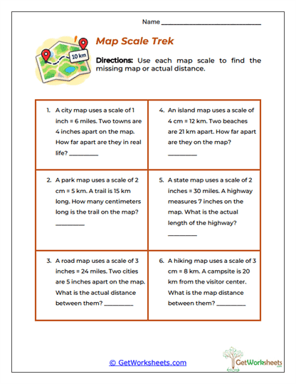
This worksheet helps students use map scales to find either a real-world distance or a distance on a map. Each problem gives a scale, such as 1 inch = 6 miles or 2 cm = 5 km, then provides one additional measurement and asks students to find the missing value. Some problems require students to scale from the map to the real world, while others work backward from the actual distance to the map measurement.
For a parent, the easiest way to explain map scales is that a small measurement on paper represents a much larger distance in real life. If 1 inch represents 6 miles, then 4 inches represents 4 times as much distance, or 24 miles. If the actual distance is given instead, the student works backward by dividing or setting up a proportion.
Learning Goals
- Interpret Map Scales: Students understand what a scale statement means.
- Find Actual Distances: Learners scale map measurements up to real-world distances.
- Find Map Distances: Students work backward from real distance to map distance.
- Use Equivalent Ratios: Learners maintain the same scale relationship.
- Work with Units Carefully: Students match inches with inches, centimeters with centimeters, miles with miles, or kilometers with kilometers.
Parent-Friendly Teaching Tips
Use this routine:
- Read the scale carefully.
- Decide whether the problem asks for map distance or real distance.
- Identify the scale factor.
- Multiply when scaling up or divide when scaling down.
- Keep the units correct.
For example:
1 inch = 6 miles
4 inches = ?
4 × 6 = 24
Answer: 24 miles
Another example:
2 cm = 5 km
15 km = ? cm
15 is 3 times 5, so:
2 × 3 = 6
Answer: 6 cm
Why This Worksheet Helps
- Makes Proportions Practical: Students see how ratios are used in maps and travel.
- Builds Unit Awareness: Matching corresponding units is essential.
- Strengthens Scaling Skills: Students practice both multiplication and division.
- Prepares for Scale Drawings: The same reasoning appears in blueprints, models, and diagrams.
- Connects Math to Geography: Map reading gives proportional reasoning a useful real-world context.
The real value of this worksheet is that it teaches students how one consistent ratio can connect a small drawing to a much larger real distance. Map measurements, actual distances, scale factors, multiplication, division, and units all work together. For parents, the best reminder is: “First decide whether you are going from the map to real life or from real life back to the map.”
Bookmark Us Now!
New, high-quality worksheets are added every week! Do not miss out!